


The Uppland Trail, section 14, 19.5 km
- Hiking
- Near Public Transport
- County: Uppsala län
- 6751.87 km away from you
Trail details
- Length 19.5 km
Actions
Description
Activities And Facilities
- Hiking
Accessibility
- Near Public Transport
Surface
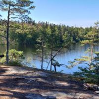
Mostly walking along small forest path.
Communications
There is a bus stop at the start and finish. It is possible to get by bus between Lövstabruk and Västland. The bus stop at the start is called Lövstabruk herrgården. At the end of the stage there is a stop at Västland church.
Directions
Lövstabruk is located along road 76, one mile south of Skärplinge. In the northern part of the community there is a parking lot at Barnens bruk.
Västland is located along the road that runs between Tierp and Karlholm. From Tierp, follow the signs for Karlholm Mill. After 15 km you will arrive in Västland. Parking is available at the church.
Contact
Email address
Upplandsstiftelsen
Organization logotype

Please be aware that some of these texts have been automatically translated.
I’ve been here 25








I want to go here 32






Reviews
3.9
1 review
- 5 :
- 4 :
- 3 :
- 2 :
- 1 :
Questions & Answers
Ask a question to other Naturkartan users.
Users images
Share your photos of the place!

Skogsetapp får man väl säga. Den här gick jag från Västland till Löfstabruk, övernattade på B&B och tillbaka nästa dag