Upptäck Öreälvsleden bit för bit
Images
-
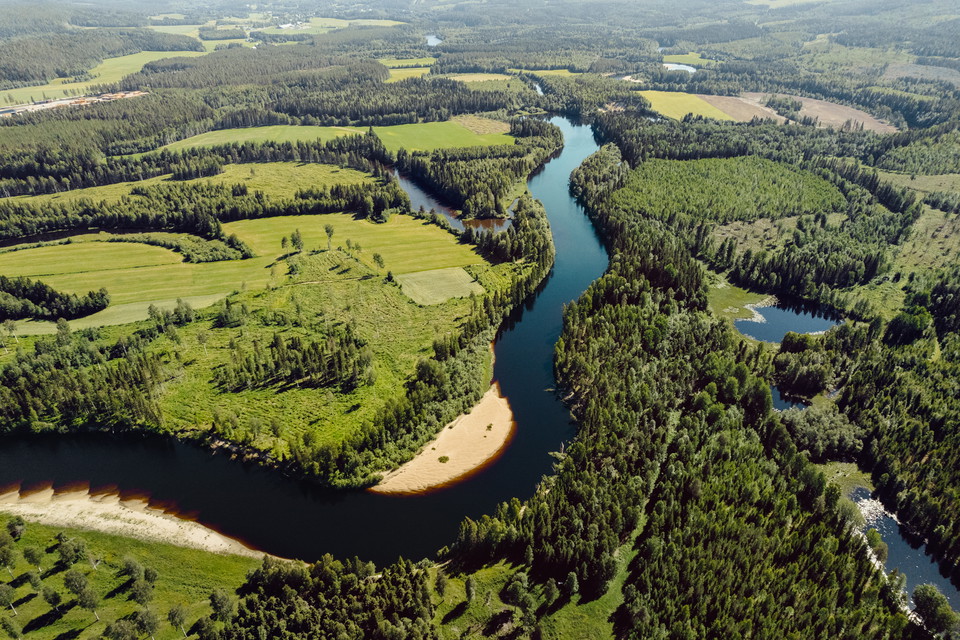
Photo: Amanda Sveed, Visit Umeå
The 110-km-long hiking trail follows the meandering Öreälven River
through its scenic valley and runs primarily through two municipalities, Bjurholm
and Nordmaling. The trail runs from Örträsk in Lycksele Municipality to Tjäruskär in
Nordmaling Municipality. The trail takes you through magnificent forest and river landscapes with high
ridges, deep ravines, as well as fields and flower-filled meadows. The section through Nordmaling
municipality is about 6 mil long.
The lower part of the trail takes you along the coastline for a while, past cliffs
and beaches; it then continues through many sites of cultural and historical interest,
including several nature reserves and biotope-protected areas. The trail is easy to walk but
includes some more challenging sections, especially where the terrain becomes hilly and
you need to climb up and down steep ridges. It’s perfectly fine to hike
shorter sections, as several parts of the trail are easily accessible by car. Along
the trail, there are also overnight cabins, picnic areas, wind shelters, outhouses, and
swimming-friendly beaches. The Öreälven River is home to sea trout and salmon. Along the entire
length of the river, there are many excellent fishing spots.
The Öre River was used for log driving during the second half of the
1700s until 1777, with the aim, among other things, of supplying the water-powered sawmill in
Håknäs with timber. Today, you can still see remnants of the
the log-driving era in the form of a well-preserved cultural landscape in Nedre Öre. In more than 200
locations, the river was modified in various ways to facilitate log driving.
Today, many rapids have been restored to their original condition thanks to
extensive restoration projects—a harmonious blend of history and nature.
Öreälvsleden – Nordmaling Municipality
Recommended Stages**Tjäruskärskajen - Långed
For a shorter hike, there are a few stages that are particularly
worth seeing; these have been selected based on suitable starting and ending points and
where the trail is both in good condition and offers a wonderful nature experience.
The Öreälven Nature and Culture Trail runs along this route.
Signs along the trail provide information about the villages’
history and other points of interest, adding value to this scenic
hike.
Stage Descriptions**
The following day stages are recommended.
Tjäruskär – Nedre Öre 10 km
The first part of the trail offers a flat and delightful hike
along the coastline with cliffs, beaches, and through idyllic archipelago scenery. The trail then takes you
along forest roads and paths through the woods and along the river mouth.
More info
Tjäruskär – Nedre Öre
Distance: 10 km Time:
Approx. 3 hours
Difficulty: Easy
Sections:
·
Tjäruskär – Kråken
Distance: 3.8 km Time: Approx. 1.5 hours
Difficulty: Easy
Distance:
3.6 km Time: Approx. 1 hour Difficulty: Easy
·
Skramla Beach – Nedre Öre
Distance: 2.5 km Time: Approx. 0.5 hours
Difficulty: Easy
Start/End – Parking Options
Tjäruskär: Park at the harbor (Tjäruskär 50)
Kråken: Park at Kråken’s
community center; signs are posted from Road 568.
Skramla swimming area: Park
on the forest road; directional signs are posted from Road 568.
Nedre Öre: Park at the boat launch,
signs are posted from Road 568 (near Nedre Öre 206).
Terrain
Description
The first section of the Öreälvsleden trail offers an easy hike
with great variety and beautiful archipelago views accessible to the public. The section
closest to Tjäruskärskajen runs along a road. After that, the trail runs largely along
the shoreline, passing summer cottage areas. After a few short detours along
a road, the trail continues on footpaths and the old Kråkenvägen past the lovely
Skramla Beach with its finest sand. After the Skramla swimming area, the
trail continues north past the narrow Kroken cove, part of the Snöan Archipelago
Nature Reserve. You then arrive at the historic setting of Nedre Öre,
Alvik, where timber was sorted during the log-driving era.
Services and
Attractions
At the trailhead on Tjäruskärskajen, you’ll find Kråkens Hamnkrog;
check the opening hours if you’re interested in visiting. After just over 3 km and 6 km,
you’ll reach lovely rest areas on rocky outcrops, with a picnic area in between at
Lerhällan and Kråken. At the Skramla swimming area, there’s a barbecue and rest area, as well as at
Kroken and Sorteringen in Nedre Öre. At Kroken, you can also take a detour
to a shallow sandy beach at the mouth of the Öreälven River. Along the trail, there are signs
set up that tell the story of the villages, which is closely tied to the log-driving era
and fishing. At Sorteringen in Nedre Öre, there are several preserved houses and
information boards about the log-driving era (to be put up in August).
Things to Keep in Mind
The trail passes through
a summer cottage area; please be considerate by staying on the trail. Bring your own firewood
if you plan to barbecue at one of the nice grill sites.
Nedre Öre – Långed 12.3 km
The trail runs on both sides of the river. You’ll pass several small rapids,
swimming spots, and points of interest, such as the area around the Strömsör Bridge and
Håknäsbacken, an idyllic little village with plenty of historical curiosities such as
an old sawmill and, on the other side of the river, an old mill.
More info
Nedre Öre–Långed
Distance: 12.5 km Time:
Approx. 3.5 hours Difficulty:
Easy, slightly hilly
Sections:
·
Nedre Öre – Öre
Distance: 4 km Time: Approx. 1 hour
Difficulty: Easy
·
Öre – Håknäs
Distance: 3.8 km Time: Approx. 1 hour
Difficulty: Easy
·
Håknäs – Långed
Distance: 4.7 km Time: Approx. 1.5 hours
Difficulty: Easy
Start/End – Parking Options
Nedre Öre: Park at the boat launch;
there is a sign from Road 568 (near Nedre Öre 206).
Öre: Park at the community center in Öre; the entrance is between Öre 17
and Öre 21. xx
Strömsör Bridge: Parking available on both sides of
the bridge abutment
Håknäs: Parking at the western bridge abutment leading to Håknäsbacken.
Signposted from Road 514 through Håknäs.
Långed: Parking at Trillan. Signposted from Road 515 toward
Långed.
Terrain
Mostly forest trails, with shorter sections on public roads or
forest roads. Some areas have light undergrowth and a few hilly sections. The trail
runs for long stretches along the banks of the Öreälven River.
Description
Wild and beautiful, a nice mix of river walks and hiking in the
forest, with several points of interest to stop at, such as old bridges with beautiful
views of the rapids, an old sawmill and mill, and the remains of a power plant. The undergrowth
in a few small sections can be quite dense
at certain times during the summer.
Services and
Attractions
Öre Mill and Bakery are located near the trail, and a little further
along the trail is Humlebäck Ceramics and Furniture Workshop. There are several picnic
and rest areas, for example in Nedre Öre (Alvik), Öre, Mjölarbacken (Strömsör Bridge),
Per-Lars Rapids, Håknäs Mill and swimming area, Trillan, and Långed (at the bridge abutment). Along
this stretch, there are also many signs providing information about, among other things,
log driving, the history of the villages, the Strömsör and Håknäs manors, the barge ferry,
the Långed power station, and the cultural landscape at Håknäsbacken.
Things to Keep in Mind
Recommended Stages **Björkudden – Tallberg Bridges
Björkudden – Hummelholm 8 km
The route runs on both sides of the river. You’ll pass several rapids and points of interest,
such as around Björkudden, the starting point for the Kulturstigen trail, which
takes you down to the rock carvings at Laxforsen, among other things. The trail takes you
further along paths, small roads, across fields, and through wooded landscapes along the river,
as well as through Torrböle and Hummelholm, idyllic villages. The stage ends at
the Hummelholms Slåtterängar Nature Reserve.
More info
Björkudden–Hummelholm
Distance: 8 km Time: About 2.5 hours Difficulty: Easy, slightly
hilly
Start/End
Parking is available at the start of the stage at Björkudden in Torrböle and
at Hummelholm’s hay meadows.
Terrain
A mix of trails and forest roads, with the final section on
a country road/gravel road through the village of Hummelholm. Some sections have light undergrowth and
a few hilly stretches.
Description
The first part takes you across the river through farmland and
the beautiful village of Torrböle. The trail mostly follows forest trails or forest roads that take
you across fields and through wooded landscapes, and in some places along the river. Be sure to
take a detour from the trail to the lovely sandy beach at Lillnäset, halfway
to Hummelholm. The final section through the picturesque village of Hummelholm follows a public
road.**
Facilities and
Attractions
At Åbroforsen lies the scenic rest area Björkudden.
There you’ll find a wind shelter, a barbecue area, tables, and an outhouse. Next to Björkudden in
the sawmill rapids, there used to be a coarse-toothed sawmill. The sawmill was first mentioned in 1754, when the villages
of Torrböle and Hummelholm jointly owned it. This is also the starting point for
the cultural trail that takes you to, among other things, the rock carvings at Laxforsen. The trail
is a loop of approximately 4 km or 2 km. The end point of this stage is at the entrance
to the nature reserve, Hummelholm’s hay meadows, a very scenic and popular
destination. Here you’ll find a wind shelter with a barbecue area, benches, and a wheelchair-accessible outdoor restroom.
Things to Keep in Mind
The trail passes through the villages of Torrböle and Hummelholm; please
show consideration by staying on the trail. Bring your own firewood if you plan
to barbecue at one of the nice barbecue areas.
Hummelholm–Tallberg 15 km
A hilly route where the trail alternates between roads,
forest roads, and trails, winding up and down the hills a short distance from the river. There are few
rest areas along the route, but the endpoints at Tallberg and Hummelholm
are very well-developed rest areas with beautiful views.
More Info
Hummelholm–Tallberg
Distance: 15 km Time:
Full day, approx. 6 hours Difficulty: Moderate/Difficult
Start/End
Hummelholm: Exit at the sign for “Hummelholm
Nature Reserve.” Park at the rest area,
which is the entrance to the reserve, where you’ll find information about the reserve and the trail.
Tallberg: Park at the Tallberg Bridges (Tallberg 80)”**
Terrain
Hilly section with some very steep slopes closer to
the Tallberg Bridges; varied terrain, including sections on forest roads and gravel paths.
Description
Closer to Hummelholm, the trail runs along the riverbank and the terrain
is also somewhat flatter.
The section near Tallberg is very hilly, with steep slopes without railings
or stairs, making it a more physically demanding hike than the stages closer to the coast.
The trail also runs slightly farther from the water than other stages, where the water is not
visible for long stretches.
Services and
Attractions
In addition to the terminal points in Hummelholm and Tallberg, there are
two designated rest areas along the route. At Gravanäsforsen, there is a simple rest area
with benches and a fire pit, and along the trail upstream of the Jon-Pers Nature Reserve, there is a seating area. In Hummelholm, there is a wheelchair-accessible outdoor toilet, benches, and a barbecue area at the nature reserve entrance. A little
further upstream, there is an overnight cabin with a barbecue area and an outdoor toilet at Holmforsen.
On the initial section of the trail, there are a few nice spots near
the water. Be sure to take a detour up to the summit in the Jon-Persbäcken Nature Reserve,
which offers beautiful views of the river and the landscape.
The endpoints at Hummelholm and Tallberg are well
worth visiting. In Hummelholm, the Hästängsholmarna Nature Reserve—especially in
June—boasts an unparalleled display of flowers, with the scent of lily of the valley right
along the trail; and Tallberg, with its three bridges from different eras. Take a short
detour from the trail so you can see the majestic Tallberg bridges both
from above and at water level.
Tallberg is located near Nyåker, where you’ll find amenities such as
a grocery store and a gas station.
Things to Keep in Mind
Some sections closer to the Tallberg bridges
are quite steep. Bring your own firewood if you plan to barbecue at one of
the nice picnic areas.
Categories
- Hiking
Contact
Email address
Kontakta Visit Umeå
Organization logotype