


The Uppland Trail, section 6, 15.5 km
- Hiking
- Near Public Transport
- County: Uppsala län
- 6809.85 km away from you
Trail details
- Length 15.5 km
Actions
Currently
Description
Activities And Facilities
- Hiking
Accessibility
- Near Public Transport
Parking
Parking is available both at the start and finish. The one at the start is quite small.
Communications
The nearest bus stop to Södersjön is Rånäs vägskäl. From here it is a 1.5 km walk along a small country road to the swimming area. In Knutby there is a bus stop Knutby vårdcentral right at the end of the stage.
Directions
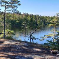
Södersjön is located a few kilometers southeast of Almunge. Take road 282, through Almunge and continue towards Knutby. Turn right at the sign for Rånäs and Almunge G.K. After 1.5 km, a small sign points down to the swimming area.
Contact
Email address
Upplandsstiftelsen
Organization logotype

Please be aware that some of these texts have been automatically translated.
I’ve been here 38



I want to go here 45



Questions & Answers
Ask a question to other Naturkartan users.
Reviews

Users images
No user images yet. Be the first to share!

Vackert med dopp vid Södersjön och äventyr med ”halvnöd”vattenhämtning vid Kolsjön som det slutade med att vi ej behövde använda pga. snälla husägare vid leden (filtreringen hade säkert funkat men onödigt att chansa). Vacker led och fina minnen (juli-25)