• Ellen Keys Strand Omberg från vattnet
    Ellen Keys Strand, Omberg sett från vattnet.
  • Ålebäcken. 
Etapp: Ödeshög-Omberg, Signaturleden. 
Ödeshög.
    Ålebäcken
  • Ålebäcken. 
Etapp: Ödeshög-Omberg, Signaturleden. 
Ödeshög
    Ålebäcken
  • Lämningar av byggnader vid Ålebäcken. 
Etapp: Ödeshög-Omberg, Signaturleden. 
Ödeshög
    Lämningar av byggnader vid Ålebäcken.
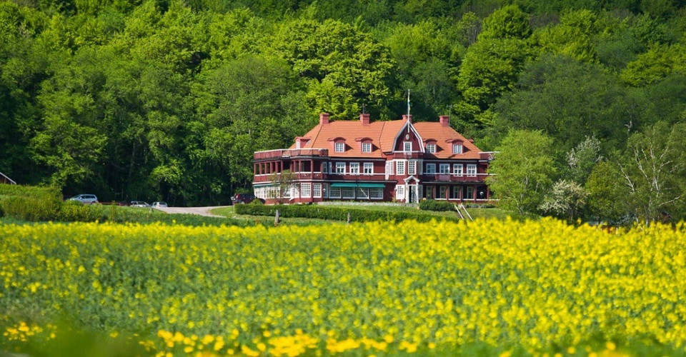
  • Bakom rapsfältet syns Ombergs Turisthotell.
Etapp: Borghamn-Alvastra, Hästholmenrundan.
Ödeshög.
    Bakom rapsfältet syns Ombergs Turisthotell.
  • Sverkerstenen. 
Etapp: Ödeshög-Omberg, Signaturleden. 
Ödeshög.
    Sverkerstenen.
  • Hällristning Hästholmen.
Omberg.
Ödeshög.
    Hällristning Hästholmen.

[Ödeshög] Hästholmenslingan, en

  • Circular trail
  • Hiking
of 5 stars

Trail details

  • Length 4.2 km
  • Difficulty Green — simple

Actions

  • Directions

Description

Translated by Google translation

A shorter loop around Hästholmen and Ålebäcken with nice views towards Omberg. The first section has a common route with the stage Ödeshög-Stocklycke.

Between Hästholmen and Ålebäcken you mainly walk on a path in open ground with a striking view of Lake Vättern and towards Omberg. There are several rocks to take a rest at or a bath.

You follow Ålebäcken a short distance inland and pass the remains of old mill facilities, which are partly medieval. At Ålebäcken there are some spans and a bridge. At the turn of October-November, you can see trout going up the stream to spawn.

Shortly after Ålebäcken, the trail splits, the trail continues west towards Stocklycke. If you follow the circular loop, you turn east. You walk on a small dirt road with a view over the fields towards Omberg and the historic Tourist Hotel on the southern slope of the mountain.

At an intersection, turn south onto a small asphalt road and follow it back towards Hästholmen. Just after the crossing is the Sverkerstenen. This marks the place where, according to legend, King Sverker was killed in 1156.

Inside Hästholmen there is a marked detour to a rock carving area with enigmatic symbols from the Bronze Age.

(2022-02-14/eb)

Weather forecast (at 12:00)

Loading…

Get here by public transport

Activities And Facilities

  • Hiking
  • Circular trail

Downloads

Contact

Address

Välkommen till Östgötaleden, 150 mils vandring i Östergötland!

Email address

Kontakt Östgötaleden

Please be aware that some of these texts have been automatically translated.

I’ve been here 3
I want to go here 5
Reviews

—

0 reviews

of 5 stars

5 :
0.0%
4 :
0.0%
3 :
0.0%
2 :
0.0%
1 :
0.0%

Questions & Answers

Ask a question to other Naturkartan users.

Users images

Share your photos of the place!

Naturkartan

Open this in the app