
-
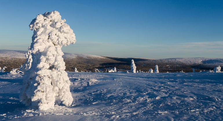
På toppen av Hundfjället är det vindpinat och kan vara riktigt kallt. Men vyn är fantastisk åt alla väderstreck!
Photo: Länsstyrelsen Dalarna
Hundfjället, Naturreservat
- Nature reserve
- County: Dalarnas län
Actions
Description
Intensive forestry over the past few decades has devoured most of our old-growth forests. The fact that a few old-growth forests still remain is often due to the terrain being so difficult to access that logging was not economically viable. The southwestern side of Hundfjället is one such place where a stretch of contiguous forest has been left untouched. Here, nature’s own drama has created a landscape of ravines, boulder fields, and old-growth trees.
Untouched Forest Offers High Biological Value
Hundfjället is located between the Norwegian border and the Västerdalälven River in the Sälen Mountains in Malung Municipality. The southern part of the mountain is a nature reserve and a Natura 2000 site covering 560 hectares. Here, the forest has remained largely untouched by humans and today possesses a biological value that qualifies it for the EU’s Natura 2000 program for the protection of valuable natural areas. Even without any prior knowledge, one can sense that the forest is untouched when seeing the gnarled spruce trees draped with hanging lichens, resembling spiderwebs in an old attic.
Inaccessible ravine landscape
In the southernmost part, an extensive ravine landscape has formed, which, together with all the boulders, has made the area inaccessible to human influence. The ravines—or “grubbor,” as they were called—are damp, and here the spruce trees seek shelter from fires.
This unique environment is home to many rare species, including the violet-gray beard lichen, the bordered polypore, the rose polypore, and the wrinkled skin lichen. Among the vascular plants of Hundfjället are spring vetch, ground buttercup, and eyebright. Many birds also thrive here: the Siberian jay, the spotted woodpecker, the capercaillie, and the three-toed woodpecker are just a few of them.
The three-toed woodpecker feeds on insects in dead tree trunks, which it persistently pecks its way into. It often leaves behind “ringed trees,” where it has pecked away the bark in a circle around the trunk. Spruce trunks where the bark has been completely stripped away can also be a sign that the three-toed woodpecker has been at work. The species has declined in Sweden and other countries where intensive forestry is practiced, but it is still found in places like Hundfjället, where the conditions for finding food remain.
Traces of Fires
Higher up in the mountains, the spruce forest gives way to sparser pine forest, pine heath, and scattered mountain birches. Here, nature is not quite as pristine, but the elevation offers a view southward over the forested landscape.
Fires have been common in these parts, as evidenced by the fire scars on old pines and pine stumps. When a fire sweeps through the forest, most trees burn up, but the thickest pines survive with only a scar on the bark. The scar forms on the leeward side of the trunk. That’s where the flames converge and the heat is most intense. After the fire, the pine tries to heal the scar by allowing the bark to curve inward, but a scar always remains—and that’s what’s known as a fire scar. On some of the stumps on Hundfjället, there are traces of six fires!
Hiking and Skiing in a Beautiful Forest
Today, Hundfjället is a place where nature is allowed to develop freely and is accessible for outdoor recreation. The Sälenringen hiking trail passes at the foot of the mountain and is kept clear to ensure easy access for visitors and passersby. You can reach Hundfjället by car via forest roads that connect to the road between Transtrand and Rörbäcksnäs.
Activities And Facilities
- Nature reserve
Facts
Bildades: 1995Storlek: 580 haKommun: Malung-SälenFörvaltare: LänsstyrelsenNatura 2000: Ingår i EU-s nätverk av skyddad natur. Om Natura 2000
Directions
The area is located 5 km south of Tandådalen on the southern slope of Hundfjället. Summer: Road 1047 between Hammarsby and Röbäcksnäs; a forest road runs northward directly below the reserve boundary. Winter: A ski trail (Sälenringen) runs through the area from Hundfjället and Högfjällshotellet.
Regulations
The following activities are not permitted in the reserve:
- climbing into nesting trees or intentionally approaching a bird of prey’s nest, lair, or den closer than 100 meters,
- damaging the ground or geological features,
- damage growing or dead trees and shrubs—whether standing or fallen—or pick or dig up herbs, mosses, wood-decay fungi, and lichens,
- light a fire anywhere other than in a designated area,
- introduce plant or animal species that are native to the area,
- ride a bicycle off-road
Without a permit from the County Administrative Board, it is also prohibited to:
- conduct military training exercises,
- engage in commercial activities.
Click on the nature reserve’s name and select the “Documentation” tab to view the documents.
Contact
Address
Email address
Organization logotype

Please be aware that some of these texts have been automatically translated.
I’ve been here 1

I want to go here 2
Questions & Answers
Ask a question to other Naturkartan users.
Reviews
0 reviews
- 5 :
- 4 :
- 3 :
- 2 :
- 1 :
Users images
No user images yet. Be the first to share!
