
-
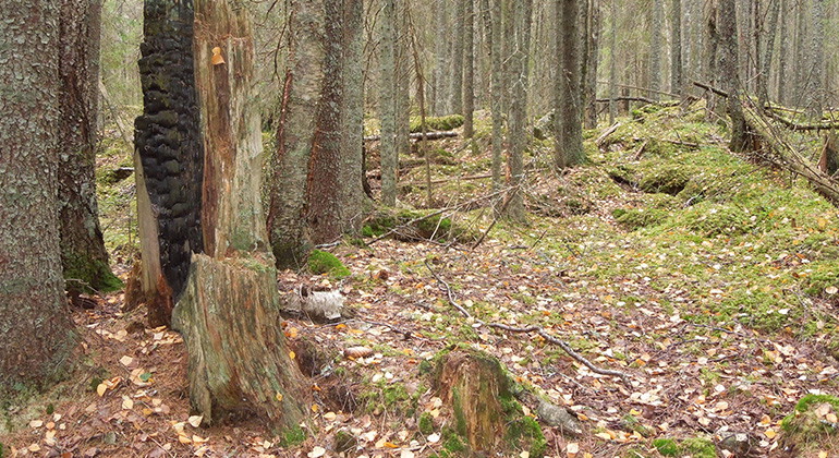
Brandstubbe. Foto Jan Rees.
Kallkärret, Naturreservat
- Nature reserve
- County: Värmlands län
Actions
Description
Natural forest and vast mires in a beautiful and undisturbed environment
Kallkärret is located on the hill west of the Klarälven river in an area characterized by fire and historically low-intensity forestry. The forest is a natural forest and is crossed by several bogs.
The older natural coniferous forest in the area has been left untouched for a long time, which has created good conditions for species associated with older forests.
There are ten documented ancient remains of the type of coal pits in the area. There are many indications that, in addition to the documented ancient remains, there are further remains not yet registered.
Animals and plants
The area consists of both wetter areas with spruce forest and pine-dominated areas. In each forest type, thanks to the microclimate and access to structures such as old trees and dead wood, there are good conditions for high biodiversity. 19 red-listed species and 23 signal species have been found in the area, including the three-toed woodpecker, the knotted woodpecker, the wood bustard, the purple-grey thorn lichen and the brown-powdered needle lichen.
Activities And Facilities
- Nature reserve
Facts
Filed: 2018
Size: 89 hectares
Landowner: Private
Administrator: County Administrative Board of Värmland
Directions
Location: Värmlands län, Torsby municipality, about 6 km SW of Stöllet. From Värnäs follow E45 about 5 km southwest towards Torsby. Turn left towards Vimyren. Follow the road about 2.2 km. There is no parking.
Regulations
In addition to other statutory provisions, it is prohibited in the reserve to
- felling or otherwise damaging living or dead trees or bushes, standing or fallen
- collect invertebrates, mosses, lichens and wood fungi,
- driving a motorized vehicle
- digging or pulling up vascular plants
- damaging, moving or removing rock, soil or stones
- bringing an unleashed dog or other stray pet.
Without the permission of the County Administrative Board, it is also prohibited to:
- carry out organized competitive, educational or outdoor activities.
Exceptions
The ban on driving motorized vehicles does not apply on existing roads or
driving a snowmobile on a trail marked with red crosses and shown on the map in Appendix 2.
The ban on bringing dogs that are not on a leash does not apply to hunting with dogs.
Contact
Email address
Maila Länsstyrelsen Värmland
Organization logotype
Please be aware that some of these texts have been automatically translated.
I’ve been here 1

I want to go here 2
Questions & Answers
Ask a question to other Naturkartan users.
Reviews
0 reviews
- 5 :
- 4 :
- 3 :
- 2 :
- 1 :
Users images
No user images yet. Be the first to share!
