
Tveta motionsspår
- Running
- Near parking
- Near Public Transport
- County: Stockholms län
- 6824.10 km away from you
Actions
Description
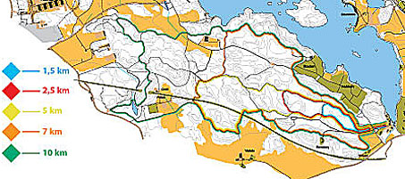
Track blue is 1.5 km long and has a gravel surface. The track is easy and has lights that turn on the runner. Remember to turn off the light when you are done.
Track red is 2.5 km and has gravel as a surface. The route is easy and has lighting that is turned on by the runner. Remember to turn off the light when you are done.
Track yellow is 5.0 km long with varied surfaces. It is described as medium difficulty and has no lighting.
The orange trail is 7 km long with varied terrain. It has no lighting.
The green track is 10.0 km long and has a varied surface. It is described as medium difficulty and has no lighting.
All exercise tracks start at Tveta Friluftsgård. Södertälje-Nykvarn Orientation is responsible for the operation.
Activities And Facilities
- Running
Accessibility
- Near parking
- Near Public Transport
Directions
By car: Highway E4 or E20 to Södertälje. Road 509 towards Järna/Nykvarn, about 3 km outside Södertälje.
By bus: 784, 785 and 789 from Södertälje Centrum, get off at the Tvetaberg stop.
Contact
Email address
Södertälje kommun
Organization logotype

Please be aware that some of these texts have been automatically translated.
I’ve been here 1

I want to go here 3

Questions & Answers
Ask a question to other Naturkartan users.
Reviews
0 reviews
- 5 :
- 4 :
- 3 :
- 2 :
- 1 :
Users images
No user images yet. Be the first to share!
