
-
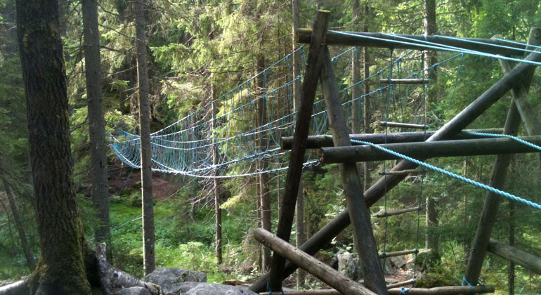
Photo: Länsstyrelsen i Dalarnas län
Slogfallet, Naturreservat
- Nature reserve
- County: Dalarnas län
Actions
Description
Slogfallet is a small mountain with steep slopes located on the eastern side of Upper Malingsbosjön. Here grows a natural spruce forest with some large aspens. Part of the reserve is influenced by limestone, as evidenced by its rich flora. There are also rare wood-decay fungi that thrive on the many dead trees.
A Variety of Habitats Suitable for Many Different Species
Slogfallet is an area that offers a diversity of habitats for plants and animals associated with natural forest. Many endangered plant and animal species are directly dependent on these habitats. The spruce trees in the forest are over 100 years old. There are many dead trees, both standing (dead standing trees) and lying on the ground (logs). As a result, many rare fungi and insects thrive here. Thanks to the presence of lime in the soil, there is also a rich flora, including, for example, green helleborine, hepatica, and snakeberry.
Scouts challenge each other here
The reserve is located just 500 meters from Kopparbo, where the Scouts hold their camp activities. The Scouts have a so-called “pioneer trail” with permanent structures in the northern part of the reserve. The pioneer trail includes a path featuring, among other things, several different types of simple bridges.
How to Get Here
From the road between Ludvika and Malingsbo, there is a turnoff toward Söderbärke. At Hedbyn, a small road leads through Kopparbo to a turnoff at the northern boundary of the reserve. From there, it’s easy to enter the reserve by following the small forest road that runs between the lake and the entire northwestern boundary of the reserve.
Apart from the Scouts’ Pioneer Trail, there are no facilities or trails for visitors in the area.
Activities And Facilities
- Nature reserve
Directions
The area is located about 10 km south of Smedjebacken, east of Övre Malingsbosjön.
Regulations
Within the reserve, it is not permitted to...
- damage the ground or geological features,
- damage growing or dead trees and shrubs—whether standing or fallen—or pick or dig up herbs, mosses, lichens, and wood-decay fungi,
- light fires,
- catch or collect animals,
- introduce plant or animal species that are native to the area,
- drive a motor vehicle off-road,
- disturb wildlife, for example by climbing nesting trees or intentionally staying closer than 100 meters to a bird of prey’s nest, den, or lair,
- bring an unleashed dog.
Click on the nature reserve’s name and select the “Documentation” tab to view the documents.
Contact
Address
Email address
Organization logotype

Please be aware that some of these texts have been automatically translated.
I’ve been here
I want to go here 6

Questions & Answers
Ask a question to other Naturkartan users.
Reviews
0 reviews
- 5 :
- 4 :
- 3 :
- 2 :
- 1 :
Users images
No user images yet. Be the first to share!
