
-
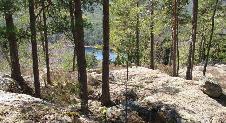
Reservatet bjuder på vacker utsikt.
Photo: Linda Stöberg
Kloften, Naturreservat
- Nature reserve
- County: Värmlands län
Actions
Description
Enjoy the view or take a look at the gorge that gave the reserve its name.
Mount Kloften rises from 170 meters above sea level at Lake Östra Buvattnet in the north, to 300 meters above sea level at the top, giving a fantastic view of the lakes below. The nature reserve includes the top of Mount Kloften, some smaller mire areas and the steep west side of the mountain. The west slope and the crack down towards Klofttjärnet are sharp, with boulders and clay surfaces. The ground below the west slope is fresh to wet and there are areas of swamp forest. In the southern parts below the west slope, the proportion of deciduous trees is high.
The forest types mixed coniferous forest and pine forest alternate in the small hilly rift valley landscape. Thanks to the fact that the area is largely inaccessible to forestry, many of the natural values that have disappeared from the ordinary forest landscape remain. Large parts of the area are of natural forest character. You can walk in old pine forests on moorland as well as on rocky areas. The oldest pines are 250-300 years old. Dead wood is found in most of the area in the form of lying and standing dry trees and dying trees. Burn marks in the form of burnt stumps show that there has been a fire in the reserve.
The nature reserve was established to preserve the valuable habitats of natural forest-like rocky pine forest and deciduous coniferous natural forest and to preserve the species that are characteristic of the habitat types in the area.
Animals and plants
The lichen flora is rich with the presence of several rare and endangered species. Among several lichens can be mentioned dwarf beaker lichen, violet-gray thorn lichen, lung lichen, and leather lichen. The leatherjacket lichen is a jelly lichen. Jelly lichens are one of the main indicators of high nature values in forest land.
The abundance of dead and dying trees favors, among others, the three-toed woodpecker and the endangered beetle, the raggbok.
Activities And Facilities
- Nature reserve
Facts
Established: 2009
Size: just under 95 hectares
Landowner: Private
Administrator: County Administrative Board of Värmland
Directions
Location: Värmlands län, Eda municipality, 8.5 km southeast of Koppom.Directions from Arvika. Drive west on road 172 past Sulvik towards Gränsjön about 15 km. Turn right at Tomten and then drive about 4 km, the road goes past Ormängen and Ördalsvägen, then keep right at Skruvtjärn to continue just under a kilometer to the parking lot on the left side of the road.
Regulations
In the reserve it is forbidden to:
- collect invertebrates such as beetles, snails or butterflies
- collecting mosses, lichens or wood fungi
- damage or remove dead wood such as lying or standing dry trees or dry branches
- driving vehicles.
Contact
Email address
Maila Länsstyrelsen Värmland
Organization logotype
Please be aware that some of these texts have been automatically translated.
I’ve been here 1

I want to go here 2


Questions & Answers
Ask a question to other Naturkartan users.
Reviews
0 reviews
- 5 :
- 4 :
- 3 :
- 2 :
- 1 :
Users images
No user images yet. Be the first to share!
