
-
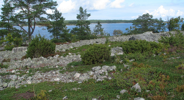
Kuggörarnas stränder är täckta av klappersten.
Photo: Länsstyrelsen Gävleborg
Kuggörarnas domänreservat, Naturreservat
- Nature reserve
- County: Gävleborgs län
Actions
Description
Kuggörarnas nature reserve consists of an island, connected to Hornslandet by a road bank about 150 meters long. In the area, you can walk along the path by the fishing village. Or take a break at the rest area and look out to sea. The cliffs, shingle fields and rocky beaches of the typical natural environment of the Norrland coast offer a great nature experience.
Natural harbor
The nature reserve is located east of Hudiksvall, in the northern part of Hornslandet and covers 51 hectares. Where a bay runs into the island and creates a natural harbor is Kuggörarnas fishing village.
Adjacent to the eastern part of the fishing village is a chapel, built in 1776-1777. The fishing village is the backbone of the valuable cultural environment and a beautiful feature of the landscape.
There are also noteworthy ancient remains on the island. In the northwestern part there is a labyrinth and on the southwestern part of the island there is a burial ground from the late Iron Age.
Old archipelago stables
The vegetation on the open ground consists of lichens, crowberry, heather, lingonberry and melon. The more fertile land is occupied by sparse low-growing pine forest, rowan and juniper. Above them, 250-300-year-old archipelago pines arch their richly branched crowns.
Activities And Facilities
- Nature reserve
Facts
Areal: 51 hektar
Skyddsår: 1996 (domänreservat sedan 1947)
Kommun: Hudiksvall
Förvaltare: Länsstyrelsen
Karaktär: Hav, sten- och klippmarker samt skog
Skyddsområde: naturreservat, Natura 2000
Directions
Island in northeastern Hornslandet, 23 kilometers east southeast of Hudiksvall.
Regulations
Special rules apply in the nature reserve. It is not allowed:
- damage any fixed object or surface formation
- damage to the forest stand, dead standing or fallen trees, brushwood, herbs or ground vegetation
- deliberately disturbing wildlife, damaging or removing endangered or rare plants and animals
- drive a motorized vehicle off-road
- camping, burning or taking firewood, except driftwood
For full regulations, see the reserve decision.
Contact
Email address
Please be aware that some of these texts have been automatically translated.
I’ve been here 5


I want to go here 1

Questions & Answers
Ask a question to other Naturkartan users.
Reviews
0 reviews
- 5 :
- 4 :
- 3 :
- 2 :
- 1 :
Users images
No user images yet. Be the first to share!
