


Akkelis fjällurskog
Naturschutzgebiet
- Landkreis: Norrbottens län
- 7481.65 km von Ihnen entfernt
Aktionen
Audio
Beschreibung
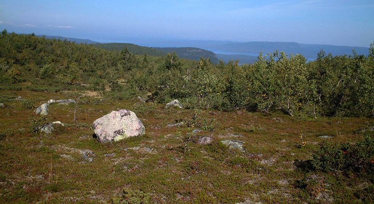
From the open moorlands closest to the summit of Akkelis, you have a fantastic view of the surrounding lake strewn landscape. A trail leads up the mountain. The highest summit of Akkelis mountain is at 784 metres. The upper areas of the reserve consist of mountain moors and exposed granite bedrock that has been washed clean. Further down on the slope an ancient spruce forest grows . There are snowmobile trails in the area. The Akkeli old-growth mountain forest nature reserve is 56 square kilometres in size.
Aktivitäten und Einrichtungen
-
Naturschutzgebiet
Fakten
Municipality: Arjeplog
Year of formation: 2000
Size: 55.5 square kilometers
Administrator: County Administrative Board
Form of protection: Nature reserve, Natura 2000
Kommunikation
From Arjeplog, it is a 16 kilometres drive. Go west from Arjeplog about 10 kilometres on road 95. Then turn north and drive towards the village of Bukt for about seven kilometres. Just south of the village, there is a parking spot where a trail starts.
Anleitung
The reserve is about 16 kilometers by car from Arjeplog. About 10 kilometers west of Arjeplog, turn north from road 95 towards Bukt. After about seven kilometers, just south of Bukt, there is a parking lot on the west side of the road.
Verordnungen
All regulations can be found in the reserve decision. It is allowed to:
- camping
- hiking
- make a fire
- picking berries and edible mushrooms
- drive snowmobiles on well-snow-covered ground
- fishing and hunting in accordance with applicable laws
It is not allowed to harm plant and animal life. Remember the right of public access and protect nature!
Kontakt
E-Mail-Adresse
Länsstyrelsen Norrbotten
Logotyp der Organisation
![]()
Bitte beachten Sie, dass einige dieser Texte automatisch übersetzt worden sind.
Fragen & Antworten
Stellen Sie eine Frage an andere Naturkartan-Nutzer.
Bewertungen
Das könnte Sie auch interessieren
