
-

Bild: Sveaskog -
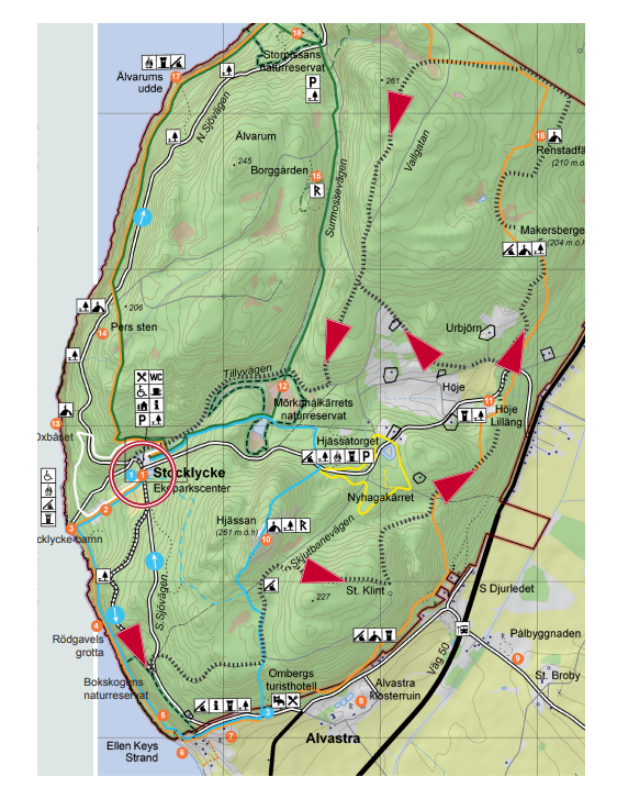
Bild: Sveaskog
Södra rundan
- Terrengsykling
- Fylke: Östergötlands län
Detaljer om stien
- Lengde 12.5 km
Handlinger
Beskrivelse
Start and finish: Stocklycke. Cycle counterclockwise. 12 km alt. 9 km.
The trail starts south along Sjövägen, asphalt road. After about 800m the trail turns sharply left and it continues on asphalt for about 70 m before it turns into a nice, easy-to-ride path that takes you up the mountain. After about 500 m you come out on a gravel road where you first turn left and at the next junction right. Soon the trail turns right onto a path into the forest. Follow it to a turning point and continue to the left, the path ends with a downhill run down a gravel road that you follow for a short distance. Here Östgötaleden's fine trails connect and take you down towards Höje Lilläng. Here you cross an asphalt road and you have to make a choice:
Short loop: If you choose the short loop, you turn left at the road choice, onto Vallgatan which takes you up to the crossroads to Surmossevägen. Here the trail turns left onto a path down to Tillyvägen, gravel road, which you then follow back to Stocklycke. 9 km.
Long loop: If you choose the long loop, you continue on Östgötaleden up towards Renstafällan's pastures. The trail offers quite demanding cycling up through the pastures but a fantastic view of the plain and Tåkern awaits you when you reach the top. In the middle of the top of the mountain, Vallgatan is crossed and you get a nice trip down again on fantastic paths. The trail ends on Tillyvägen, gravel road, down towards Stocklycke. 12 km.
Please note that the trails are shared with pedestrians - show consideration and give way.
Aktiviteter og fasiliteter
- Terrengsykling
Kontakt
Adresse
Kontakta Sveaskogs kundcenter vid frågor.
E-postadresse
Jeg har vært her 1
Jeg ønsker å dra hit
Spørsmål og svar
Still et spørsmål til andre brukere av Naturkartan.
Omtaler
0 anmeldelser
- 5 :
- 4 :
- 3 :
- 2 :
- 1 :
Brukernes bilder
Ingen brukerbilder ennå. Bli den første til å dele!
