
-
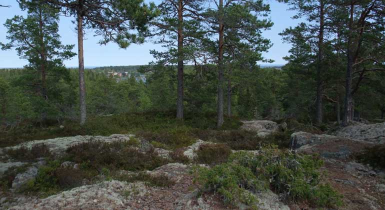
Utsikt över lantlig bebyggelse från Skämningön.
Foto: Länsstyrelsen Gävleborg
Skämningsön, Naturreservat
- Naturschutzgebiet
- Landkreis: Gävleborgs län
Aktionen
Beschreibung
Skämningsöns nature reserve is located on a headland on the coast. The area is mainly of interest as an excursion destination, so you can walk, walk the dog or jog on the path around the reserve. On the southernmost headland there is a shelter and a barbecue area. Hillviken has a beach with a sandy bottom.
Skämningsöns nature reserve is located 1 kilometer southwest of Gåsholma and covers 22 hectares. Here, coniferous forest grows on the headland with a rocky pine forest on the higher parts. It is mainly pine but also occasional birch and spruce. A mixed coniferous forest grows in the remaining areas. Several very old and large pine and spruce trees grow along the eastern shore. Other species that grow in the area are saltwort, snake's tongue, hay flower and beach mallow.
Burial cairn and harbor site
On the top of the mountain there are burial cairns and the remains of a springhouse. The harbor, which is located just north of the reserve, has been a known port since the Middle Ages. Fishing has been a major source of livelihood in the area.
Moose, roe deer and hare occur within the reserve. Nesting birds in the area are the great spotted woodpecker, the common crow, the willow warbler and the marsh warbler. Other species observed in the area are greater and lesser crossbill, sparrowhawk, capercaillie and black grouse.
Aktivitäten und Einrichtungen
- Naturschutzgebiet
Fakten
1971 Fläche: 22 Hektar Zeichen: Wald, Küste und Strand Gemeinde: Gävle Manager: Kreisverwaltung Gävleborg
Anleitung
Naturreservatet ligger 1 kilometer sydväst om Gåsholma. Från E4 norr- och söderifrån: Sväng av E4:an vid Axmar tavla och kör mot Axmar by. Efter 7 kilometer sväng höger in på Gåsholmavägen och kör cirka 6 kilometer så ligger reservatet på höger sida. Fortsätt cirka 600 meter för parkering.
Verordnungen
Im Naturschutzgebiet gelten besondere Vorschriften. Es ist nicht gestattet,
Schäden an festen Gegenständen oder Oberflächenbildung
- Auswirkungen auf den Waldbestand, Reis, Kräuter oder Bodenvegetation
- absichtlich stören die Tierwelt, zum Beispiel durch die Nähe der Fotografie, durch das Klettern der Nestbäume oder durch die Möglichkeit des Hundes, den Appell zu jagen Kraftfahrzeuge Zelt oder Aufstellung eines Wohnwagens Feuern Sie.
Für vollständige Regelungen siehe Reserveentscheidung.
Kontakt
E-Mail-Adresse
Bitte beachten Sie, dass einige dieser Texte automatisch übersetzt worden sind.
Ich bin hier gewesen 1
Ich möchte hierher gehen 3

Fragen & Antworten
Stellen Sie eine Frage an andere Naturkartan-Nutzer.
Bewertungen
0 Rezensionen
- 5 :
- 4 :
- 3 :
- 2 :
- 1 :
Bilder von Nutzern
Es gibt noch keine Nutzerbilder. Sei der Erste, der eines hochlädt!
