
-
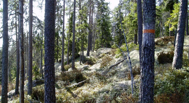
Jämmerdalen.
Foto: Länsstyrelsen
Jämmerdalen, Naturreservat
- Naturreservat
- Fylke: Örebro län
Handlinger
Beskrivelse
The Jämmerdalen nature reserve is named after one of several narrow rift valleys in the reserve. The forest in the area is dominated by spruce forest that is dense, shady and swampy. In the northern part of the reserve, the landscape opens up around Småtjärnarna. The Bergslagsleden trail also passes through the reserve here.
Mighty rift valley terrain
The Jämmerdalen nature reserve is located in the very hilly terrain east of Norra Finnfall. Three rift valleys dominate the reserve. They are from south to north: Jämmerdalen, Lilla Oxdalen and Skitibacksdalen. Between and around the rift valleys are eleven smaller mountain peaks. Kvarndalen is located in the westernmost part of the reserve.
Forest fires in Jämmerdalen
The inaccessible steep slopes, blocky ridges and narrow rift valleys have meant that most of the forests have been untouched for a long time. Parts of the forest are also affected by fire. Several of the old pines have traces of at least one forest fire.
Plants and animals
Jämmerdalen has good access to shady boulders, rock walls and clay surfaces where moisture remains even on the driest summer days. Some of the threatened species found here are the rare mosses northern rock tussock, southern button moss and shadow moss. One of the threatened lichens found in the reserve is the Norwegian lichen, which grows on rock walls, boulders and spruce in the reserve. There is at least one capercaillie playground in the nature reserve. One of the most famous woodpeckers in the old-growth forest, the three-toed woodpecker, often nests in the forests of Jämmerdalen.
Woodpeckers cleared land
Many Finns came to Ljusnarsberg in the late 16th and early 17th centuries. They settled on the heights around the lakes and cleared small fields by slash-and-burn agriculture, which is why they are called "slash-and-burn Finns". Small areas in the forest were cleared and burned. Rye was then sown in the ashes. Norra Finnfall, southwest of the reserve, tells the story of the area's Finnish history through its name.
The time of the huts
The forests of Bergslagen show more or less clear traces of the charcoal cutting and charcoal burning that was practiced in the forests from the 17th century to the 1940s. The Svedjefinners who settled here and took possession of the forests now had to stop felling and burning the forest. Large quantities of coal were needed for the production of iron and copper, so extensive coal mining was carried out in the forests around the smelters. At Jämmerdalen, the northern and western parts of the area were known as 'smelting forest'. The remains of the coal mine, the coal bed, usually consist of a circular slight elevation in the ground 5 - 8 meters in diameter.
The mill by the stream
In the northwestern part of the reserve runs Kvarnbäcken. There was once a mill here. Today you can still see the boulders that formed the foundation of the mill building. A bit upstream of the ruin is a millstone left in the middle of the stream.
Aktiviteter og fasiliteter
- Naturreservat
Fakta
Municipality: Ljusnarsberg
Year established: 2005
Area: 163.4 hectares
Landowners: Swedish Environmental Protection Agency and individuals
Manager: County Administrative Board
Reserve creator: County Administrative Board
Veibeskrivelse
The Jämmerdalen nature reserve is located about 7 km northeast of Kopparberg. From highway 50 you take road 233 towards Kloten. After about 6.5 km, at the farm Norra Rifallet, there is a parking lot with an information board on the east side of the road. Follow a forest road for about 2 km to the southern part of the reserve. You can also reach the reserve via Bergslagsleden stage 1, which runs through the northern part of the reserve.
Forskrifter
In the reserve it is prohibited to:
- damage the surface of the ground
- Bringing an unleashed dog
- Disturbing wildlife
- pick flowers, lichens or wood-living fungi or otherwise damage the vegetation. However, berries and edible mushrooms may be picked
- collecting insects or other invertebrates
- making carvings on dry trees or bark or damaging lying tree trunks
- camping and building huts
- drive a motorized vehicle or ride a bicycle other than on public roads
- putting up a board, notice, poster or similar device
- set up orientation controls or organize marked trails
Kontakt
E-postadresse
Organisasjonens logotype
Jeg har vært her
Jeg ønsker å dra hit
Spørsmål og svar
Still et spørsmål til andre brukere av Naturkartan.
Omtaler
0 anmeldelser
- 5 :
- 4 :
- 3 :
- 2 :
- 1 :
Brukernes bilder
Ingen brukerbilder ennå. Bli den første til å dele!
