
-
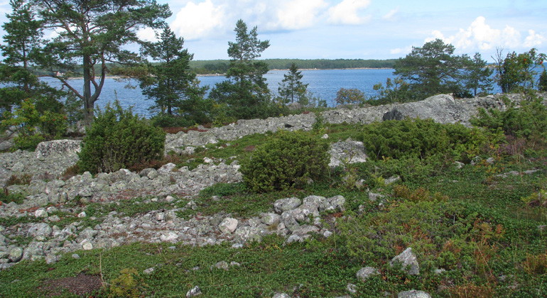
Kuggörarnas stränder är täckta av klappersten.
Foto: Länsstyrelsen Gävleborg
Kuggörarnas domänreservat, Naturreservat
- Naturschutzgebiet
- Landkreis: Gävleborgs län
Aktionen
Beschreibung
Kuggörarnas nature reserve consists of an island, connected to Hornslandet by a road bank about 150 meters long. In the area, you can walk along the path by the fishing village. Or take a break at the rest area and look out to sea. The cliffs, shingle fields and rocky beaches of the typical natural environment of the Norrland coast offer a great nature experience.
Natural harbor
The nature reserve is located east of Hudiksvall, in the northern part of Hornslandet and covers 51 hectares. Where a bay runs into the island and creates a natural harbor is Kuggörarnas fishing village.
Adjacent to the eastern part of the fishing village is a chapel, built in 1776-1777. The fishing village is the backbone of the valuable cultural environment and a beautiful feature of the landscape.
There are also noteworthy ancient remains on the island. In the northwestern part there is a labyrinth and on the southwestern part of the island there is a burial ground from the late Iron Age.
Old archipelago stables
The vegetation on the open ground consists of lichens, crowberry, heather, lingonberry and melon. The more fertile land is occupied by sparse low-growing pine forest, rowan and juniper. Above them, 250-300-year-old archipelago pines arch their richly branched crowns.
Aktivitäten und Einrichtungen
- Naturschutzgebiet
Fakten
Fläche: 51 Hektar Schutzjahr: 1996 (Hauptreserve seit 1947) Gemeinde: Hudiksvall Manager: Bezirksrat Charakter: Meer, Stein und Felsen und Waldschutzgebiet: Naturschutzgebiet, Natura 2000
Wegbeschreibung
Island in northeastern Hornslandet, 23 kilometers east southeast of Hudiksvall.
Verordnungen
Im Naturschutzgebiet gelten besondere Vorschriften. Es ist nicht gestattet:
Schäden an festen Gegenständen oder Oberflächenbildung
- Auswirkungen auf die Waldbevölkerung haben, stehende oder gefallene Bäume, Reis, Kräuter oder Bodenvegetation töten Beeinflussen Sie Tiere, Schäden oder entfernen Sie gefährdete oder seltene Pflanzen und Tiere Führen Sie Kraftfahrzeuge im Gelände
- Zelt, Feuer oder Holz nehmen, gilt nicht
Für vollständige Regelungen siehe Reserveentscheidung.
Kontakt
E-Mail-Adresse
Bitte beachte, dass einige dieser Texte automatisch übersetzt worden sind.
Ich bin hier gewesen 5


Ich möchte hierher gehen 1

Fragen & Antworten
Stellen Sie eine Frage an andere Naturkartan-Nutzer.
Bewertungen
0 Rezensionen
- 5 :
- 4 :
- 3 :
- 2 :
- 1 :
Bilder von Nutzern
Es gibt noch keine Nutzerbilder. Sei der Erste, der eines teilt!
