Tio toppar Tavelsjö - Vallberget

  • Wandern
von 5 Sternen

Details zum Weg

  • Länge 0.8 km
  • Zeit 55 min
  • Schwierigkeit Schwarz – erfahren

Aktionen

  • Wegbeschreibung

Beschreibung

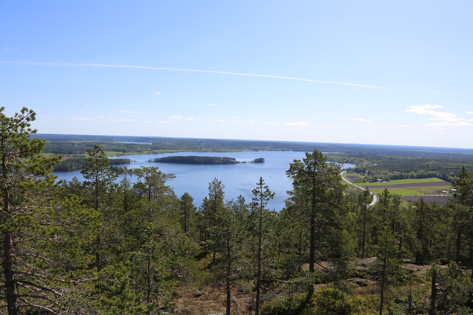
Five lakes, one sea, five lighthouses and one city! The top of Vallberget offers a view for miles. On clear days you can see Holmöarna in the distance and with binoculars the lighthouses Stora Fjäderägg, Bergudden, Holmögadd and Nordvalen. With extremely good visibility and sharp binoculars, you can see the Valsörarna lighthouse in Finland, 82 km from Vallberget

In addition to Lake Tavelsjön, you can see lakes Avan, Trehörningen, Haddingsavan and Smörsjön. The top of Vallberget is on the highest coastline. This is where the sea reached when the ground was at its most depressed after the heavy ice sheet released its grip. At the top there is a viewing tower and wind shelter. A cliff in the mountain is popular with climbers. In the cliff on the north side of the mountain is Vallbergs[1] cave, large and difficult to reach. An easier path to the top via Tavelsjöleden is on the other side of the mountain

Wettervorhersage (um 12:00 Uhr)

Wird geladen…

Mit öffentlichen Verkehrsmitteln anreisen

Aktivitäten und Einrichtungen

  • Wandern

Fakten

268 m

Kontakt

E-Mail-Adresse

Kontakta Visit Umeå

Bitte beachte, dass einige dieser Texte automatisch übersetzt worden sind.

Ich bin hier gewesen 8
Ich möchte hierher gehen 27

Bewertungen

—

0 Rezensionen

von 5 Sternen

5 :
0.0%
4 :
0.0%
3 :
0.0%
2 :
0.0%
1 :
0.0%

Fragen & Antworten

Stellen Sie eine Frage an andere Naturkartan-Nutzer.

Bilder von Nutzern

Teile deine Fotos von diesem Ort!

Naturkartan

Öffne dies in der App.