Stenbergsleden

  • Wandern
4.095811051693405 von 5 Sternen

Details zum Weg

  • Länge 3.7 km

Aktionen

  • Wegbeschreibung

Beschreibung

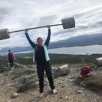
The entire trail is about 3 km, of which 1.5 km is on the pebble ridge with water on both sides. After 0.5 km you can look out on the east side over Gammel-gården and Voijen, where one of the first settlers in Graninge settled in the 16th century. After 1 km of hiking, you will find a shelter with a fireplace by the lake shore on the west side. Opposite, you can take a swim at the old bathing place Kattisjen. If you continue another few hundred meters, you walk over water on a bridge structure that replaced the old footbridge that was demolished in the 50s.

The trail is marked with red painted crosses placed at regular intervals.

Wettervorhersage (um 12:00 Uhr)

Wird geladen…

Mit öffentlichen Verkehrsmitteln anreisen

Aktivitäten und Einrichtungen

  • Wandern

Parken

A few parking spaces are available.

Kontakt

E-Mail-Adresse

Majed Safaee

Ich bin hier gewesen 5

Ich möchte hierher gehen 11
Bewertungen

4.1

1 Rezension

4.095811051693405 von 5 Sternen

5 :
0.0%
4 :
100.0%
3 :
0.0%
2 :
0.0%
1 :
0.0%
4 von 5 Sternen

En kortare liten runda, hela leden är väl upptrampad och lätt att gå. Jag började åt andra hållet (ville avsluta med delen där man går över rullstensåsen), då är det dock betydligt svårare att se markeringarna, den är gjorde för att gå åt ett håll. Blåste kallt som tusan i I början av april men i vindskyddet blev det nästan varmt!

Fragen & Antworten

Stellen Sie eine Frage an andere Naturkartan-Nutzer.

Bilder von Nutzern

Teile deine Fotos von diesem Ort!

Naturkartan

Öffne dies in der App.