
-
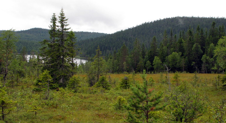
Norra Havsjön. Foto Dick Östberg.
Havsjöskogen, Naturreservat
- Naturreservat
- Amt: Värmlands län
Handlinger
Beskrivelse
Lakes surrounded by forested hills.
Havsjöskogen is an elevated plateau where the lower Havsjöarna lakes with their surrounding bog mosaics are surrounded by some of the highest mountains in the county. In the south is Värmland's highest mountain, Granberget, which measures 701 meters above sea level. The natural environment is very varied and the area contains large unbroken natural forests, wetlands and a number of fine watercourses.
The natural forests in the area range from fire-affected natural pine forests and deciduous burns to high-altitude spruce forests
The lake system with its streams and rivers is one of the county's most valuable as the watercourses are relatively unaffected by the rafting.
Animals and plants
The relatively large area of unfragmented natural forest, the unbroken
forest continuity and the amount of structures such as dead wood, old late-growth trees, etc. mean that the number of signal and red-listed species is large. Below is a selection of red-listed species and signal species that have been found in the area (threat category according to the Species Database Red List 2020 in brackets where NT = near threatened, VU = vulnerable and EN = highly threatened and S = signal species according to the Swedish Forest Agency):
Birds
Three-toed woodpecker (NT)
Stone Crow (NT)
White-throated sparrow (NT)
Wolverine (NT)
Capercaillie (S)
Grey woodpecker (S)
**Insects
Brown lion (S)
**Vascular plants
Praying mantis (VU)
Coral root (S)
Spindle flower (S)
Spotted knapweed (S)
Torta (S)
Marsh Marigold (S)
Snakeberry (S)
**Lichen
Broktagel (EN)
Long brook nettle (EN)
Norwegian beak lichen (VU)
Aspergillus lichen (VU)
Violet-grey thorn lichen (NT)
Hull lichen (NT)
Lung lichen (NT)
Dwarf beaker lichen (NT)
Pinnate yellow lichen (NT)
Knotted bladderwort (NT)
Brown-powdered needle lichen (NT)
Wolf lichen (NT)
White-shafted black spike (NT)
Wood slice lichen (NT)
White-spotted needle lichen (NT)
Short-shafted spadefoot (NT)
Shiny black spike lichen (NT)
Blue-gray black spike (NT)
Dark coal lichen (NT)
Charcoal lichen (NT)
Stump lichen (S)
Bearded lichen (S)
Louse lichen (S)
Coral lead lichen (S)
Spawning lichen (S)
Shadow blue lichen (S)
Leather lichen (S)
Dwarf tufa (S)
Yellow needle (S)
**Fungi
Grass spurge (VU)
Wrinkled skin (VU)
Fragrant skin (NT)
Old spruce bark (NT)
Spruce budworm (NT)
Starry thorn (NT)
Woolly tick (NT)
Spruce tick (NT)
Flesh tick (NT)
Large aspen tick (S)
Fox tick (S)
Wood tick (S
**Mosses
Wood stair moss (NT)
Flagellated tussock moss (S)
Dark house moss (S)
Western hook moss (S)
Forest hook moss (S)
Red listing is the classification of plant and animal species according to an assessment of their risk of extinction. Signal species is a term used for species that act as indicators when trying to distinguish biotopes with high natural values.
Facilities
The nature reserve is affected by the Nordvärmlandsleden hiking trail, which runs between Höljes in the north to Branäs in the south. Adjacent to the trail at Kvarnsjön there is a windbreak and fireplace. The shelter is also adjacent to one of the snowmobile trails that run through the area. The hiking trail continues and goes past Värmland's highest peak, Granberget. On the top of Granberget there is a lookout tower with a magnificent view of the reserve and the surrounding landscape with blue mountains and both Norwegian and Swedish mountains.
Aktiviteter og faciliteter
- Naturreservat
Fakta
Established: 2021
Size: 1605 hectares
Landowners: State and private
Manager: County Administrative Board in Värmland County
Rutevejledning
The reserve is located in Värmlands län, Torsby municipality, about 5 kilometers east of Höljes. There are two main ways to reach the nature reserve. From Höljes: From road 62, turn over the river and into Höljes. Follow the road in a left turn and a right turn and then turn right at a crossing. After about 800 m turn left and follow the road for 2.5 kilometers and then turn right. Now follow this road for just under three kilometers and then turn right. After another three kilometers on this road you will reach the border of the nature reserve. Note that the last six kilometers of the road is a snowmobile trail in winter so this part is not plowed. From Sysslebäck: Continue north for about 9 kilometers. Turn east at the sign for Granberget. Follow the road for about 12 kilometers to the next sign for Granberget. Take the bridge over Tåsan and follow the road for about 8 kilometers to the start of the hiking trail towards Granberget's lookout tower. You can also reach the reserve via the Nordvärmlandsleden hiking trail, which runs between Höljes in the north and Branäs in the south.
Regler
In addition to other statutory provisions, it is prohibited in the reserve to
- felling or otherwise damaging living or dead trees or bushes, standing or fallen
- collect invertebrates, mosses, lichens and wood fungi,
- driving motorized vehicles
- tipping or stockpiling.
Without the permission of the County Administrative Board, it is also prohibited to:
- conduct organized competitions or outdoor activities.
Exceptions
The regulations prohibiting the use of motorized vehicles do not apply on existing roads or for driving snowmobiles on trails marked on the map in Appendix 2 or for driving on sea ice marked on the map in Appendix 2.
Kontakt
E-mailadresse
Maila Länsstyrelsen Värmland
Organisationens logotype
Jeg har været her 1
Jeg vil gerne derhen 2

Spørgsmål og svar
Stil et spørgsmål til andre Naturkartan-brugere.
Anmeldelser
0 anmeldelser
- 5 :
- 4 :
- 3 :
- 2 :
- 1 :
Brugernes billeder
Der er endnu ingen brugerbilleder. Vær den første til at dele et!
