
-

-
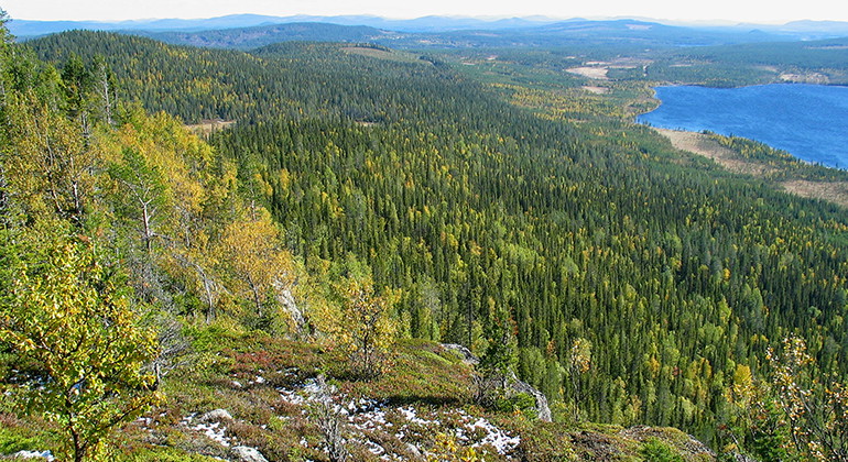
Utsikt från Harrejaureliden.
Foto: Länsstyrelsen Norrbotten
Harrejaureliden
- Naturreservat
- Landsdel: Norrbottens län
Handlinger
Beskrivelse
Harrejaureliden comprises a large mountain complex covered by virgin forest. The largest and highest mountain, Harrejaureliden, rises to 645 metres a s l. The mountain lies in the middle of the area and has a steep drop of 200 metres on the south side. From here you enjoy a magnificent view. The area is 9.8 square kilometres in size and in the southwest borders on Reivo.
Aktiviteter og faciliteter
- Naturreservat
Fakta
Municipality: Arvidsjaur
Year of formation: 2009
Size: 9.8 square kilometers
Administrator: County Administrative Board
Form of protection: Nature reserve
Kommunikationsflows
The nature reserve lies about 10 kilometres southwest of Moskosel. Follow road 45 which runs between Moskosel and Arvidsjaur. Turn off towards Tjappsåive. Northwest of the village there are logging roads that lead to the reserve.
Rutevejledning
The nature reserve is located about 10 kilometers southwest of Moskosel. Follow road 45 between Moskosel and Arvidsjaur. Turn towards Tjappsåive, northwest of the village there are forest roads leading to the reserve.
Regler
All regulations can be found in the reserve decision. It is allowed to:
- camping
- hike
- make a fire, remember to bring your own wood!
- pick berries and edible mushrooms
- drive snowmobiles on snow-covered ground
- fish and hunt in accordance with the laws in force
It is not allowed to harm plant and animal life. Remember the right of public access and protect nature!
Kontakt
E-mailadresse
Länsstyrelsen Norrbotten
Organisationens logo

Jeg har været her
Jeg vil gerne derhen 3

Spørgsmål og svar
Stil et spørgsmål til andre Naturkartan-brugere.
Anmeldelser
0 anmeldelser
- 5 :
- 4 :
- 3 :
- 2 :
- 1 :
Brugernes billeder
Der er endnu ingen brugerbilleder. Vær den første til at dele et!
