
-
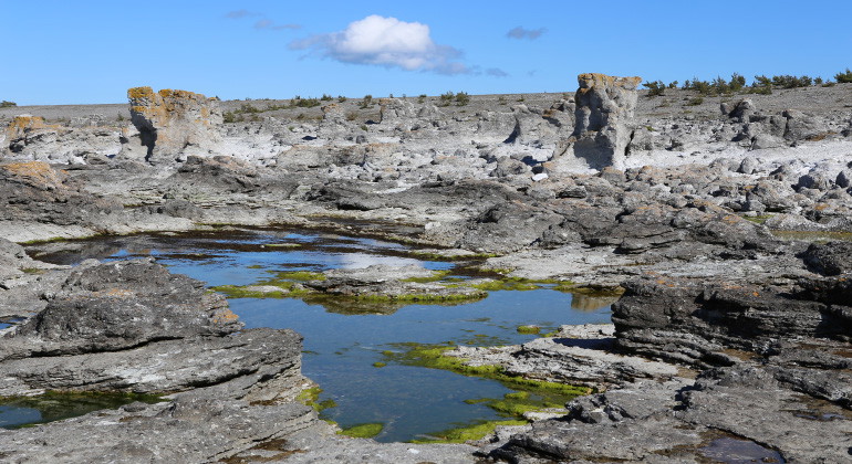
Raukfältet som sträcker sig utmed reservatet. Bilden är tagen med havet bakom ryggen.
Digerhuvud, Naturreservat
- Naturreservat
- Amt: Gotlands län
Handlinger
Beskrivelse
The Digerhuvud nature reserve stretches along the northwest coast of Fårö, from Lauterhorn in the southwest to Helgumanen fishing village in the northeast. A paved road runs through the reserve, making the various parts of the area easy to reach. At times there may be many visitors here, but the area's rauks are enough for everyone - you can always find your own rauk to climb, explore or rest your back against.
The rauks vary in height from a few meters up to 8 meters. The outermost rauks stand some way out into the water and are still being worked by the sea waves. A low cliff runs in front of the rauk field, and within this a shingle field up to 200 meters wide spreads out, almost completely devoid of vegetation. Even further in, a low-growing forest of windswept beach pines extends.
The Gotland bedrock is largely made up of coral reefs that formed in a tropical sea around 430 million years ago, during the Silurian period. Between these fossilized reefs are layers of limestone and muddy marlstone. After the last ice age, just over 10 000 years ago, Gotland was initially completely covered by water. However, freed from the weight of the ice masses, the land gradually rose above sea level. Where land and sea met, the waves could work the bedrock. The reef bodies themselves resisted the abrasion of the waves better than the surrounding layered rocks, and when the water receded, they were able to remain as isolated stone pillars - rauks. The rauks are made of hard, unconsolidated limestone and are remnants of the ancient reefs that gave rise to present-day Gotland. Both the reef limestone and the bedded limestone are rich in fossils of the many different kinds of animals that lived on and around the reefs: stromatoporoids, corals, shells, cephalopods, bryozoans, armadillos and sea lilies.
Aktiviteter og faciliteter
- Naturreservat
Fakta
Year of protection: 1930
Parish: Fårö
Character: Raukar
Area: 113 hectares
Landowners: Private
Administrator: County Administrative Board of Gotland
Type of protection: Nature reserve
Regler
For everyone's well-being and to maintain the reserve's natural and cultural values, it is important that all visitors show consideration. In addition to the right of public access, it is not allowed to:
- destroy or damage solid natural objects or surface formations by, for example, knocking fossils out of rauks or other solid rock,
- break branches, fell or otherwise damage living or dead trees or bushes,
- making a fire other than in a designated place,
- bring an unleashed dog, except for the period November 1 - January 31,
- drive a motorized vehicle other than on designated roads,
- park other than in specially designated places,
- camp or set up a house or trailer
- affix a billboard, poster, poster, sign, inscription or similar device.
Kontakt
E-mailadresse
Länsstyrelsen i Gotlands läns naturvårdsförvaltning
Organisationens logotype
Jeg har været her 16


Jeg vil gerne derhen 4

Spørgsmål og svar
Stil et spørgsmål til andre Naturkartan-brugere.
Anmeldelser
0 anmeldelser
- 5 :
- 4 :
- 3 :
- 2 :
- 1 :
Brugernes billeder
Der er endnu ingen brugerbilleder. Vær den første til at dele et!
