
-
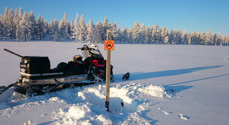
I Våmhuskölen får man bara köra skoter på skoterleden, som passerar genom områdets sydvästra hörn. Här är Länsstyrelsens naturbevakare ute för att se över områdets skötsel. Under sådant arbete är det tillåtet att köra skoter.
Foto: Per Ax, Länsstyrelsen i Dalarnas län
Våmhuskölen, Naturreservat
- Naturreservat
- Amt: Dalarnas län
Handlinger
Beskrivelse
In the hilly landscape of Våmhuskölen, traces of traditional mountain pasture farming blend with the future’s march toward primeval forest landscapes. Here, the vast marshes and barren pine forests offer visitors a primeval forest-like natural setting where only the imagination sets limits.
Visitor Information
Directions, Parking, and Hiking Tips
If you want to take the hiking trail leading to Skuråsen, there is a small parking lot 4 km north of Kölkojan, just north of the road leading to the transmission tower. See the map link under “How to Get Here.” There is a road sign here that reads “692 möh.” This parking lot is plowed even in winter.
The trail begins at the road sign and is 11 km one way. It passes Malmborgskojan after 5.3 km (locked cabin) and a wind shelter after another 1.2 km. The trail runs through both the Norra Mora Wilderness and the Våmhuskölen Nature Reserve.
From Mora: Våmhuskölen is just over 5 mil north of Mora. Take Highway 70 and turn off at Rot. About 3 mil north of Rot, on Road 1029 toward Lillhärdal, you’ll pass a large parking lot for snowmobilers called Kölkojan. The boundary of the Våmhuskölen Nature Reserve lies 2.5 km north of the parking lot.
The Ridge That Divides the Waters
Våmhuskölen is part of a large wilderness area, free of roads, that borders the Stopån, Anjosvarden, and Norra Mora Vildmark nature reserves. Kölen is situated 600–700 meters above sea level and is the highland range that separates the Dalälven and Ljusnan rivers. This location results in a climate with high precipitation and long winters.
Unique Flora and Fauna
During the summer months, vast expanses of marshland emerge, covered with golden-yellow carpets of sedges and reeds. The climate, combined with the bedrock—which consists of granite and porphyry—creates a species-poor yet unique plant and animal community.
Beautiful birds and vibrant lichens
The marsh is visited by a number of fascinating birds—the large, heavy forest bird, the capercaillie, and the small, dainty willow grouse. If you’re lucky, you might even spot the majestic whooper swan, which, unlike the mute swan, has a yellow beak rather than an orange one. The sparse forest is home to plenty of dead standing trees. These are trees—mostly pines here—that have died but stubbornly remain standing. Dead trees are the perfect “living room” for both insects and lichens. The spectacular wolf lichen is one of its inhabitants, taking hold on the dry wood surfaces and surprising visitors with its yellow-green, almost luminous color.
Mowing, grazing, and fire have left their mark
To some extent, the forests are almost like ancient primeval forests, home to species typical of this particular forest type. The pine forests here grow so slowly that time takes on a different dimension. The marsh vegetation still bears traces of the haymaking that took place here around the turn of the last century. It’s hard to imagine that people made their way all the way out here, a long way from the nearest villages, to harvest marsh hay.
The sparse forest appears wild and untouched, but the area has a history of mountain pasture farming and forestry. During the summers of the 19th century, grazing animals from the villages of Heden and Bäck roamed here. Back then, the bleating of the sheep and the sounds of the shepherd’s horn echoed across the landscape. Grazing likely contributed to the sparse forests that remain to this day, while the marshes were kept open by haymaking.
Occasional dry summers have also seen fires rage through the area, leaving open spaces that the white moss has partially taken over.
And you—take the opportunity to practice your “kulning” skills out on the marsh. Who knows? Maybe the shepherdesses will answer!
Aktiviteter og faciliteter
- Naturreservat
Rutevejledning
The area is located about 3 mil north of Rot and can be reached from the road between Rot and Sveg.
Regler
In the nature reserve, it is not permitted to...
- drive a motorized vehicle, except when the vehicle is a snowmobile and it is being driven on a marked snowmobile trail when the ground is covered with snow,
- dig up or pick herbs, mosses, and lichens,
- damage dry trees or windfalls.
Click on the nature reserve’s name and select the “Documentation” tab to view the documents.
Kontakt
Adresse
E-mailadresse
Organisationens logotype

Jeg har været her 1
Jeg vil gerne derhen 1

Spørgsmål og svar
Stil et spørgsmål til andre Naturkartan-brugere.
Anmeldelser
0 anmeldelser
- 5 :
- 4 :
- 3 :
- 2 :
- 1 :
Brugernes billeder
Der er endnu ingen brugerbilleder. Vær den første til at dele et!
