Nyhet!

Nu kan du dela dina bilder på Naturkartan! 📸

Czytaj więcej
  • Zdjęcie: Maria Blomkvist, Länsstyrelsen i Dalarnas län.
  • Zdjęcie: Länsstyrelsen i Dalarnas län
  • Zdjęcie: Länsstyrelsen Dalarna
  • Zdjęcie: Länsstyrelsen Dalarna
  • Zdjęcie: Länsstyrelsen Dalarna
  • Zdjęcie: Länsstyrelsen Dalarna

Hornbobrändan, Naturreservat

  • Rezerwat przyrody
  • Blisko parkingu
z 5 gwiazdek

Akcje

  • Wskazówki dojazdu

Opis

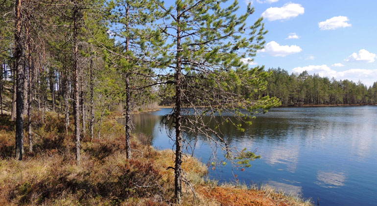
Hornbobrändan consists mainly of an older pine forest that shows clear traces of forest fires. On the ground most blueberry rice grows, with elements of lingonberry and heather. In the wetland Pisstrandfly in the northern part of the area, dwarf birch, Labrador tea and hare's tail grow. In the middle of the area there is a band of smaller wetlands and swamp forests with a stream that goes down to Ågsjön. In the southern part is Knut's tar, a small round woodland.

Most of the Hornbobrändan burn consists of a light older pine forest. Repeated fires have created a pine forest with plate-crowned old trees and younger trees involved. Here are trees with fire sounds, as well as dry cakes and stumps with charcoal residues. Despite the presence of carbon bottoms and stumps after a dimensional felling - logging where you only cut trees over a certain gravity - the area has a striking natural forest emblem. A large part of the forest is about 130 years old, but there are older trees that are up to 270 years old. In the humid low-lying part there is an area with large-grown asparagus and dead wood of both aspen, birch, fir and pine.

There is a marked trail that goes through the northern part of the nature reserve. The path goes into the forest behind a large relocation block which is located by the road, follows the ridge towards the northeast and continues out of the nature reserve in the north end. There is another small path into the reserve that goes from the road and into Knut's lake.

Prognoza pogody (o godz. 12:00)

Wczytywanie…

Dojazd środkami transportu publicznego

Działania i udogodnienia

  • Rezerwat przyrody

Dostępność

  • Blisko parkingu

Fakty

Bildades: 2017Storlek: 134 haKommun: FalunFörvaltare: LänsstyrelsenNatura 2000: Ingår i EU-s nätverk av skyddad natur. Om Natura 2000Beskrivningen av områdets Natura 2000-värden går att läsa i skötselplanen nedan.

Parking

W zachodniej części rezerwatu przyrody, gdzie droga, która biegnie z obszaru w kierunku północno-zachodnim, jest stary żwir, który znów rośnie. W obliczu żwiru znajduje się duży żwir, na którym można zaparkować.

Wskazówki dojazdu

Reservatet ligger i Falu kommun, cirka 6 km sydöst om Vintjärn.

Regulamin

I reservatet är det förbjudet att:

  • skada växande eller döda – stående eller omkullfallna – träd, stubbar och buskar, med undantag för insamling av löst liggande, mindre, torra grenar och kvistar i syfte att göra upp eld.
  • framföra motordrivet fordon i terrängen på barmark.

Vidare är det förbjudet att utan Länsstyrelsens tillstånd:

  • gräva upp växter, plocka mossor, lavar och vedlevande svampar eller samla in djur (till exempel insekter).

Ta del av föreskrifter, beslut och skötselplan i sin helhet via Naturvårdsverkets verktyg Skyddad natur

Klicka på naturreservatets namn och välj fliken ”Dokumentation” för att ta del av dokumenten.

Kontakt

Adres

lansstyrelsen.se/dalarna

Adres e-mail

Należy pamiętać, że niektóre z tych tekstów zostały przetłumaczone automatycznie.

Byłam tu

Chcę tu iść 1

Opinie

—

0 recenzji

z 5 gwiazdek

5 :
0.0%
4 :
0.0%
3 :
0.0%
2 :
0.0%
1 :
0.0%

Pytania i Odpowiedzi

Zadaj pytanie innym użytkownikom Naturkartan.

Zdjęcia użytkowników

Udostępnij swoje zdjęcia tego miejsca!

Naturkartan

Otwórz to w aplikacji