


Flottarleden Runemo-Söräng
- Vandring
- Gåtur
- Løb
- Kanosejlads
- Trail-løb
- Parkering i nærheden
- Tæt på offentlig transport
- Tæt på toilettet
- De bedste steder i Voxnadalen
- Amt: Gävleborgs län
- 6633.05 km fra dig
Ruteoplysninger
- Længde 7.0 km
- Tid 2 h
- Sværhedsgrad Blå – mellem
Handlinger
Beskrivelse
Aktiviteter og faciliteter
- Gåtur
- Løb
- Vandring
- Kanosejlads
- Trail-løb
- De bedste steder i Voxnadalen
Tilgængelighed
- Parkering i nærheden
- Tæt på offentlig transport
- Tæt på toilettet
Fakta
Log floating down the Voxnan River lasted for over a hundred years, ending in 1966. At its peak, about 5 million logs were floated per year.
In 1998, the restoration of parts of the environments that existed during the logging era began, including a 7 km long hiking trail that ran between Runemo and Söräng.
Follow the link to the Flottarleden website if you are interested in renting the Vildmarksbastun/Flottarkojan.

Overflade
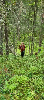
Narrow path with varied surface. Roots and stones in places. At times, the trail can be wet depending on the season and water flow in the river.
Bakker
Nästintill ingen kupering.
Parkering
If you choose to start in Runemo, you can park by the pond. There are tables, barbecue facilities and a toilet. The trail then starts on the other side of the road. There is also a parking lot in Söräng, see position in the map.
Kommunikation
In Runemo, the trail starts about 500 m from the nearest bus stop "Runemo". Line 100, which runs between Söderhamn and Edsbyn, passes here. In Söräng, the nearest bus stop is called "Sörängs skola", it is located about 1.5 km from the start of the trail. Line 100, for example, also passes here.
Rutevejledning
Starting from Runemo: Take the road towards Gäddvik, after the bridge park by the pond at the bathing area parking lot. Then follow the road north and you will see the starting point of the trail directly on the right.
Starting from Söräng : Turn in at the school then turn left at the first two Y-junctions towards Staterna. At the 3rd Y-junction Klitten there is parking on the right after the railroad. Then follow the orange markings (on the left), from the crossing to the start of the trail at the former axe forge. If you choose to start at the hut, keep straight ahead at the 3rd Y-junction towards Staterna. At the turnaround where the public road ends there is a parking lot, then walk about 300 meters to the trail. It is also periodically possible to drive all the way to the hut, but it is at your own risk.
Kontakt
Adresse
Naturkartan Voxnadalen är en karta som är tänkt att samla allt för den som vill utforska Voxnadalen på egen hand. Vandringsleder, badplatser, höga naturvärden, utsikter, häftiga platser. Här samlar vi både kommunala anläggningar, ideella föreningars anläggningar (bidra gärna om ni saknas) och platser som finns på privat mark som kan vara intressanta för besökare i vårt biosfärområde. Ambitionen är att vi tillsammans bygger och bidrar till den bästa besöksguiden i Hälsingland.
E-mailadresse
Biosfärområde Voxnadalen
Jeg har været her 19






Jeg vil gerne derhen 33




Spørgsmål og svar
Stil et spørgsmål til andre Naturkartan-brugere.
Anmeldelser
Brugernes billeder
Der er endnu ingen brugerbilleder. Vær den første til at dele et!

väldigt mysig led. barn fixar den lätt.
Tack för recensionen! Roligt att leden uppskattas - och ja den passar väldigt bra för alla!
Kan vara lite blött om fötterna vid vissa tider, beroende på hur mycket vatten det är i älven, men det går oftast bra att runda...