
-
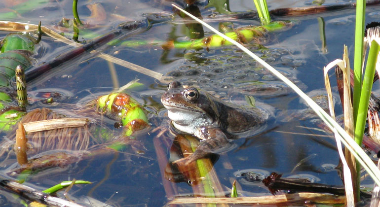
Foto i bildspel: Thomas Jågas och Länsstyrelsen, Åsa Pokela.
Agnmyren, Naturreservat
- Naturreservat
- Amt: Dalarnas län
Handlinger
Beskrivelse
Agnmyren is located on Sollerön, in the northern part of Lake Siljan. The site is known for the frog spawning that takes place here every year. There is also an interesting fault scarp here, which was designated a natural monument as early as 1986. The best time to visit this nature reserve is, of course, in the spring! When the frogs are breeding, a spectacular show unfolds right at visitors’ feet.
Photo: Thomas Jågas.
What can you do here?
Hiking trail and rest area
See lots of frogs in April–May
Agnmyren is a small pond, known in the Siljan area as one of the largest breeding grounds for the common frog. The species is not only common but is actually called the “common frog.” In late April and early May, thousands of these frogs gather in the pond to mate.
A small number of marsh frogs and smooth newts are also present. The reason for the abundant amphibian population is that there are no fish in the pond. The nutrient-rich pond provides a large amount of decaying plant matter. This leads to the formation of hydrogen sulfide, which kills any fish and benefits the frog tadpoles.
What makes this place unique?
Fascinating Geology
Agnmyren is located in the northwestern part of Klikten, the fault scarp that runs across Sollerön in a north-south direction. In the southeastern part of the reserve is a small limestone quarry, called “Silvergruvan,” where minerals such as zinc blende and galena were mined. Remnants of the mining, known as “warp,” are visible as mounds nearby. The fault scarp is home to a limestone-rich flora with an abundance of hepatica.
Agnmyren receives calcareous spring water from the steep slope in the eastern part of Klikten. This calcareous water contributes to the lush vegetation in the pond, as does the surrounding farmland.
Rich Bird Life
Bird life is abundant in the area, even though the pond is small. Its proximity to other bird-rich areas, such as the Norrviken Natura 2000 site, attracts many species to Agnmyren. Reed warblers, sedge warblers, and water rails have been spotted here.
All thrive in the reeds and can be difficult to spot. You’ll have to try to identify them by their calls. Reed warblers and sedge warblers have a trilling song that sounds similar. The water rail has a somewhat more distinctive call—it can be likened to an angry pig squealing!
Archaeological Sites
A Stone Age spear point has been found in Agnmyren. The area around Agnmyren has a long history of farming and settlement, and Stone Age graves have been found further up in the fault valley. Several of the ancient remains are registered with the Swedish National Heritage Board.
Along Agnmyren are sites where slag has been found, as well as a burial ground with stone settings, mounds, and cairns believed to date from the end of the Viking Age. The land closest to Agnmyren has been used for haymaking and, in the late 1800s, also for peat extraction.
Parking
Parking
If you have limited mobility, there is a small parking area available at the nature reserve; other visitors are asked to use the parking lot at Hembygdsgården or the small-boat harbor located at the end of Bengtarvsvägen.
Please note that during the frogs’ mating season, we close off the final section of the roads because the risk of running over frogs is very high.
A nice alternative is to park at the Hembygdsgården and walk the 3.2 km-long cultural trail that passes through the reserve.
Map and description of the cultural trail, Sollerön Local History Association’s website
Aktiviteter og faciliteter
- Naturreservat
Rutevejledning
The area is located in the northeastern part of Sollerön, about 10 km southeast of Mora.
Regler
The following activities are not permitted in the reserve:
- damaging growing or dead trees—whether standing or fallen—as well as stumps and shrubs,
- building fires,
- camping or setting up a house trailer or travel trailer,
- drive motorized vehicles off-road, whether on bare ground or snow-covered ground,
- dig up plants, pick mosses, lichens, and wood-dwelling fungi, or collect animals (such as insects),
- organize or conduct competitions and camp activities,
- ride a bicycle or horse except on marked trails,
- damage the ground or geological features, or damage boulders and rocks—for example, by chiseling, drilling, or chopping,
- bring a dog that is not on a leash.
Click on the nature reserve’s name and select the “Documentation” tab to view the documents.
Kontakt
Adresse
E-mailadresse
Organisationens logotype

Jeg har været her
Jeg vil gerne derhen
Spørgsmål og svar
Stil et spørgsmål til andre Naturkartan-brugere.
Anmeldelser
0 anmeldelser
- 5 :
- 4 :
- 3 :
- 2 :
- 1 :
Brugernes billeder
Der er endnu ingen brugerbilleder. Vær den første til at dele et!
