
Nybrännan, Naturreservat
- Naturreservat
- Amt: Värmlands län
Handlinger
Beskrivelse
High plateau with lakes and forests.
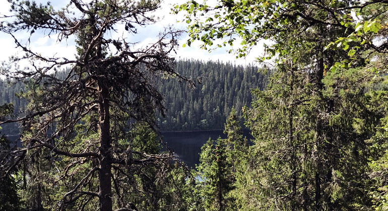
The Nybrännan nature reserve is located on a high plateau with heights of 500-600 meters above sea level. The area covers 135 hectares and extends over the hilly terrain from the heights between Lake Västersjön and Lake Mellansjön to the heights by the Baltic Sea. The heights and the pristine nature of the lakes in the area give it a wilderness character, which is an important part of its current and future value.
The reserve is named after the hill in the eastern part, which is called Nybrännan on the map. No clear signs of previous forest fires have been found, which is why the area, despite its name, has probably burned fairly or very rarely.
Stumps from earlier felling are found here and there, but recent felling has been limited.
Nybrännan is dominated by old spruce forest at high altitude. The forest is varied, with tall old spruces in areas with moving soil water and better quality, and areas with gnarled old spruces with top breaks caused by the exposed location at high altitude.
The availability of dead wood is good in places and old flames are mixed with newer ones. The forest is patchy and light in parts, but also has parts with darker areas where the forest is dense and tall. The area has a relatively large element of deciduous trees, mainly rowan, but also birch. In the area there are also scattered pine overhangs with curved branches and armored bark. The old trees and the presence of older deciduous trees make the area an important habitat for red-listed and threatened species. The area has plenty of steep slopes with boulders and mudflats that further contribute to the variation in the area.
In the lower parts of the area there are long, narrow and open bogs with poor vegetation of alternating ristuve, soft matting and hard matting types. There is also water here in the form of the Baltic Sea, part of Lake Mellansjön and Mellansjöbäcken.
Animals and plants
The area is a very suitable environment for species associated with deciduous and pristine mixed coniferous forests. The following conservation species have been found (threat category according to the Species Data Bank Red List 2020 in brackets where NT = near threatened and VU = vulnerable):
Lung lichen (NT)
Yarn lichen (NT)
Hull lichen (NT)
Stool lichen Signal species
Norwegian beak lichen (VU)
Purple-grey spine lichen (NT)
Shade blue lichen Signal species
Brown-powdered needle lichen (NT)
Old spruce bark (NT)
Coral lead lichen Signal species
Spruce tick (NT)
Wood tick Signal species
Large aspen tick Signal species
Fragrant skin (NT)
Wireworm Signal species
Red listing is the classification of species of flora and fauna according to an assessment of their risk of extinction. Signal species is a term used for species that serve as indicators when trying to distinguish biotopes with high natural values.
Aktiviteter og faciliteter
- Naturreservat
Fakta
Established: 2021
Size: Approximately 135 hectares
Landowner: Private
Manager: County Administrative Board of Värmland
Rutevejledning
Location: Värmlands län, Torsby municipality, about 4 kilometers west of Kärrbackstrand. Drive road 62 south past Sysslebäck to Höljes. From Höljes drive about 1 kilometer north and turn left towards Rangen. After about 5.5 kilometers, turn left straight south, drive about 7 kilometers. On this road you also pass the nature reserve Enberget. The last 7 kilometers to the reserve, the forest road is quite bad with pits and holes so drive slowly and carefully.
Regler
In addition to other statutory provisions, it is prohibited in the reserve to
- felling or otherwise damaging living or dead trees or bushes, standing or fallen
- collect invertebrates, mosses, lichens and wood fungi,
- driving a motorized vehicle
- tipping or stockpiling
- digging or pulling up vascular plants
- damaging, rearranging or removing rock, earth or stone.
Without the permission of the County Administrative Board, it is also prohibited to:
- carry out organized competitions or outdoor activities.
Exceptions
The regulation prohibiting the use of motorized vehicles does not apply to driving snowmobiles on trails marked on the map in Appendix 2.
Kontakt
E-mailadresse
Maila Länsstyrelsen Värmland
Organisationens logotype
Jeg har været her
Jeg vil gerne derhen 1

Spørgsmål og svar
Stil et spørgsmål til andre Naturkartan-brugere.
Anmeldelser
0 anmeldelser
- 5 :
- 4 :
- 3 :
- 2 :
- 1 :
Brugernes billeder
Der er endnu ingen brugerbilleder. Vær den første til at dele et!
