-
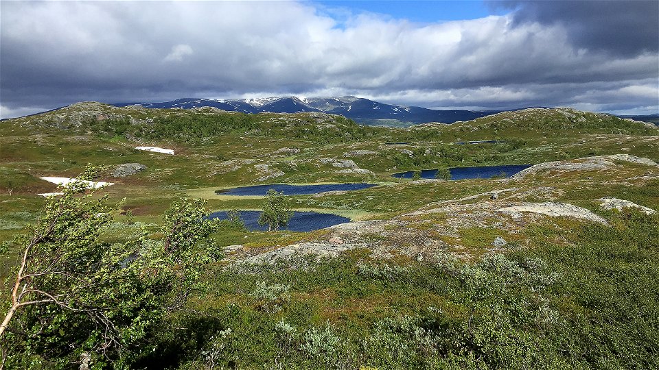
Foto: Maria Söderberg


Silvervägen/Guoledisjávrre-Guijaure-Vuoggatjålme
Wandern
- Landkreis: Länsstyrelsen Norrbottens län
- 6345.8 km von Ihnen entfernt
Details zum Weg
- Länge 52.0 km
Aktionen
Beschreibung
Some describe this hike as a ”mini-Badjelánnda (Padjelanta)”, others as a unique tour in the Swedish mountains where you will hardly meet another hiker.
Silvervägen – Lomtjärn, 17 km
You start at Lake Guoledisjávrre, where there is a large car park with a gushing stream, a wind shelter and latrine. Right from the start you are on a treeless mountain, slowly climbing for 2½ km. At the top of Själbmá height there is an ancient mine area 200 m from the trail. After c. 6 kilometres, at the slope of Njallavárddo, there is a crossing where the trail turns south. The hiking is easy, passing small lakes and watercourses.
After 1½ kilometres you come to Lake Alep Njallajávvre. The ground becomes rockier and at the southern part of the lake you find yourself in mountain birch forest. There are many ancient remains here. After the lake, the trail climbs above the tree line across slowly rising terrain. You walk alongside Gráttasjåhkå stream. There are fine places to pitch a tent here. Further ahead, the stream is passed by wading at a spot marked on the map. The trail markings are unclear just before and just after the wade.
After 3 kilometres you reach the Lomtjärnsstugan cabin, which lies c. 200 metres off the trail. A lot of osier grows in the area and it can be hard to find the trail. In the cabin, one room is open for stopovers. There is a stove, gas cooker and access to a latrine. There are also two overnight rooms which are locked and must be pre-booked. You book and rent the key through Vuoggatjålme cabin village.
Lomtjärn-Guijaure, 15 km
After the cabin there will be some difficulties with high vegetation and marshy ground. On the left side Gujjávrtjårro mountain towers 1,306 m asl. and on the other side of the water Vávlátjårro mountain at 1,386 m asl. There are some plankways along the stretch, but you can count on some wet areas along the trail, osier and rocky terrain. Lifting your gaze, you will see a fantastic valley between two dramatic mountainsides.
Where the 9 km lake rounds off, you see the Guijaure cabin. The overnight room in the cabin must be pre-booked. You book and rent the key through Vuoggatjålme cabin village. One room is open to day visitors. There is a gas cooker, basic kitchen equipment and stove. It is an excellent place to pitch a tent. Guijaure is historically a meeting place for reindeer herders, hunters, anglers, and those involved in transport for the mine that was started in 1635 at Nasafjäll.
Guijaure-Silvervägen, 20 km
Ahead of you, you have partially dense and impenetrable birch and osier forest, and wetlands crossed by plankways. Do not miss seeing Moor King and other wildflowers along your hike. The trail follows the north-east side of Lake Stuorsavvun, which gradually tapers off until its waters form Ruonekjåhkå stream. You hear the roar of the water through practically the whole hike down to Lake Sädvvájávrre. The waterfall where Ruonekjåhkå empties into Lake Sädvvájávrre is impressive. It has however been reduced by the impact of hydropower projects.
At the waterfall you turn off to the north-east and follow the shore for c. 6 kilometres to the Silvervägen Road. From this finishing point you can walk 1 kilometre along Silvervägen southwards to Camp Polcirkeln where there is a shop. Along a road heading north, it is another 3 kilometres to the cabin village of Vuoggatjålme.
Duration: Total 2–3 days
Aktivitäten und Einrichtungen
-
Wandern
Fakten
Lomtjärn-Guijaure-Vuoggatjålme, Arjeplogfjällens bästa tredagarstur?
Bloggen Gå på tur, av Nenne Åman
Utflyktsguide Själbmátjåhkkå, Arjeplogs kommun (2020)
Utflyktsguide Gujjávrtjårro, Arjeplogs kommun (2020)
(Swedish)
Oberfläche
Varied surface. Varies from easily–hiked mountain moor and treeless flat rocks to wet areas and dense osier vegetation. The trail is not always visible. Restoration of the trail is planned in 2022–2024.
Kommunikation
Guoledisjávrre nature rest area lies at road 95, Silvervägen, 30 kilometres north-west of Vuoggatjålme. A bus runs from Arjeplog to Sandviken (bus stop on road 95) at Sandvikens Fjällgård. From the bus stop to the starting point at the nature rest area at Lake Guoledisjávrre the distance is c. 17 kilometres.
Since the start at Guoledisjávrre and the finish at Vuoggatjålme lie c. 30 km from each other, two cars are required, or a ride between start and finish. Alternatively, you can make your hike a circuit by continuing to follow the marked trail on from Vuoggatjålme, via Seldutvágge Valley back to the car park at Guoledis. The hike is then c. 90 kilometres.
Länstrafiken Norrbotten website
Arjeplog Taxi, +46 (0)960-303 50, bokning@arjeplogtaxi.se
Arjeplog Lapland website
Kontakt
E-Mail-Adresse
Länsstyrelsen Norrbotten
Logotyp der Organisation
![]()
Fragen & Antworten
Stellen Sie eine Frage an andere Naturkartan-Nutzer.